Ghana in Pictures: 80 Free Photos and Travel Information
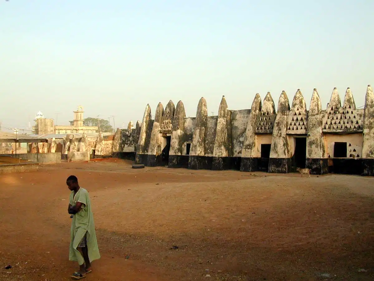
Ghana in 80 free photos: the white castles of the old Gold Coast at Cape Coast and Elmina, the canopy walkway over the rainforest of Kakum, the village of Nzulezo built on stilts over a lake, fishing canoes on palm-lined beaches, the markets of Kumasi and a kente weaver at his loom, the mud mosque of Larabanga in the north, and everyday village life. Each set of photos has a short note on the place; the travel information follows below.
Ghana at a glance
- Getting there: Kotoka International Airport in Accra. Most visitors need a visa and a yellow fever vaccination certificate.
- Getting around: domestic flights to Kumasi and Tamale, comfortable STC and VIP buses between the cities, tro-tro minibuses and taxis locally.
- Money: Ghana cedi. Mobile money is everywhere; carry cash outside the cities.
- When to go: November to March, the dry season; from December to February the harmattan wind brings dust and haze from the Sahara.
How to download: click a photo to see it large, then use Download. The originals are about 1200 × 800 pixels: right for blog posts, slides, social media, school projects and video call backgrounds.
Cape Coast, Elmina and the castles of the coast
Along the coast stand the forts and castles built by Portuguese, Dutch, Danish and British traders, now on the UNESCO World Heritage list. Elmina Castle, begun in 1482, is the oldest European building south of the Sahara. Cape Coast and Elmina were centres of the Atlantic slave trade; guided tours lead through the dungeons to the “Door of No Return”. The towns around them are lively fishing ports.


Kakum and the rainforest
In Kakum National Park, north of Cape Coast, a canopy walkway of rope bridges hangs some 40 metres above the forest floor, among the crowns of the great trees. Go early in the morning for the birds.


Monkeys and wildlife
Monkeys live in the forests and in sacred groves, where villages protect them; vultures, birds of prey and, in the north, elephants and antelope in Mole National Park.


Nzulezo and the lagoon villages
Nzulezo, near Beyin in the far west, is a village built entirely on stilts in Lake Tadane. Visitors reach it by dugout canoe through a wetland of reeds and water lilies; the walkways, school and church all stand over the water.


Fishing villages and beaches
Ghana’s coast is some 500 km of sand and palms. In the fishing villages, brightly painted canoes are launched through the surf at dawn and hauled back up the beach in the afternoon, when the catch is sold.


Kumasi, the markets and the crafts
Kumasi, the capital of the Ashanti kingdom, has Kejetia, one of the largest markets in West Africa. In the villages around it, weavers make kente, the bright woven cloth of narrow strips, and potters, tailors and painters work in the open.


The north: Larabanga and Wa
The north is dry savannah, with cattle, round houses and mud-built mosques. The white mosque of Larabanga, in the Sudano-Sahelian style, is said to be the oldest in Ghana, and lies at the gate of Mole National Park; Wa is the main town of the Upper West.


Village life
Children and families, schoolgirls in uniform, games and buses, roadside signs and the daily walk with loads carried on the head.


More about Ghana
Ghana Pictures and Travel Information. The Republic of Ghana was created in 1957, when the British colony, the Gold Coast, gained independence, the first sub-Saharan nation to do so. The name Ghana was chosen to reflect the ancient Empire of Ghana, which once extended through much of west Africa.
Ghana suffered several coups before Lt. Jerry Rawlings took power in 1981 and eventually restored a multiparty political system. Ghana, with a total area of approaching 240,000 sq. km is located in west Africa between the Ivory Coast and Togo and borders the Gulf of Guinea.
The country has a population of around 30 million (2018) and its capital, Accra, has around 2.25 million inhabitants, the Accra agglomeration around 4 million.
Accra has developed from its former role as the capital of the British-ruled Gold Coast from 1877 into a modern metropolis with a mix of British colonial buildings and skyscrapers. The city is now a cultural and tourist hub with hotels, restaurants and nightclubs.
Ghana’s population growth rate is less than 2% and life expectancy (at birth) is about 60 for men and 62 for women. Ghana is well endowed with natural resources. Agriculture involving mainly small landholders employs about 50% of the working population.
Gold and cocoa production are major sources of foreign exchange. It is expected that the recent start (2010) of oil production will provide a much needed boost to the economy, as the country has been heavily in debt for some time. Ghana remains very dependent on international financial and technical assistance.
Some interesting facts on travelling to and in Ghana: the country has 11 airports, but only 7 have paved runways; it has over 62,000 km of roads, but only about 10,000 km are paved.
When to go
Ghana has a tropical climate and is hot and humid, especially near the south coast. The ‘dry season’ is December to April, but that is also the hottest time of year, with temperatures in the 30˚s C. The best time to go is probably July/August, which is usually when there is no rain in the south but temperatures are a little cooler.
What to see in and take Ghana Pictures
Accra and the Coast: the south coast of Ghana is more or less a 500 mile long beach fringed with palm trees, and most visitors go to there for a beach holiday. In Accra Bojo Beach is a popular destination, as it is a bit out of the way and unspoiled – so far.
You pay a fee to spend the day there, which includes a boat trip, as the beach is only accessible from the sea. However there is a restaurant and they organise parties. For a family or anyone seeking some fun, Marvels in Dzorwulu is a unique place to spend a day.
There is an 18-hole crazy golf course, fast food in the Clubhouse, and other games like chess and Monopoly to play. They also put on special events, including regular Karaoke.
For some history of Ghana, head for the Kwame Nkrumah Memorial Park to see the former President’s mausoleum and a museum to his memory. 32 km (20 miles) north of Accra is the Aburi Botanical Gardens, with lawns and a collection of trees and plants from Ghana and abroad.
You can picnic there, but take your own food as there are few facilities. A day trip from Accra will take you to Shai Hills Reserve, where you can see baboons, parrots and antelope. You can rent horses to ride in the reserve.
Ghana Pictures and Travel Information
Other destinations: Mole National Park in the north is the place to see the widest range of animals, including elephant and lions. You are not allowed out of the hotel complex on foot unless accompanied by a ranger.
Cape Coast is a city a 3-hour bus ride from Accra, with a number of forts which supported the slave trade. Cape Coast Castle is a UNESCO World Heritage slavery site – a guided tour takes 40 minutes. The beach is good and local fishermen provide some extra interest.
To get close to tropical rainforest, go from Cape Coast to Kakum National Park one hour’s drive away for the “canopy walk” , a long suspended rope walkway that takes you among the tree tops and close to the birdlife. (Not suitable if you are nervous of heights.) There is a museum and café.
Warnings: Ghana requires you to have a Yellow Fever immunisation, and as West Africa is a malarial area, you should consider whether to take a prophylactic, especially if you are travelling around.
Tap water should never be drunk in Ghana, and avoid uncooked street food – fruit is OK if you peel it yourself. Not all taxi drivers are licensed and you need to agree the price before getting in – assume the driver is asking about double the real rate because you are a tourist!
Traffic is heavy in the cities and road signs are few, so you might want to stick to organised tours rather than hiring a car.
More free photos
- South Africa pictures
- Egypt pictures
- Tunisia pictures
- Mauritius pictures
- Free tropical backgrounds
- Free beach pictures
- Free market pictures
- Free palm tree pictures
- Africa pictures
Questions about these Ghana photos
Can I use these Ghana pictures for free?
Yes, for personal and commercial projects. All we ask is a link back to BigFoto.com; the box at the top of the page has a credit link you can copy.
What is the best way to visit Nzulezo?
Go from Beyin, on the coast west of Takoradi: the visitor centre arranges a guide and a dugout canoe, and the trip through the wetland to the village takes about an hour each way.